Just a reminder that this Monday’s trip is still on. The weather forecast is cooperating — sunny, cool, and low wind. The road has dried out well. There are still a few muddy puddles, but they are easy to go around. Also, the solar construction crew got their act together over the holidays and improved the first half of the road.
Hope to see you all there!
MarekC
Hi, fieldtrip friends,
This trip is on very short notice– it was originally planned for Jan 3rd but got delayed to allow the mud to dry and avoid difficult road conditions after the Holidays rains. We will revisit one of the old-school rockhounding areas in the Mojave desert — Lonely Butte, a.k.a. Brown Butte. There is a large-scale solar plant construction around the turnoff from Hwy 58, and the extra traffic has impacted the dirt road conditions. It should be manageable for regular SUVs, though. Despite a few new ruts, the 4×4 is not a must if the driver is careful.
We went there almost six years ago and had a lot of good collecting despite the cold wind. Here is the old report with great photos of the fossils: Lonely Butte, Mar 7, 2020 (updated)
I recalled that trip when reading an excellent article about Lonely Butte in the recent Rocks & Minerals. The material is petrified cattail (rare and not reed as I believed before), rushes, palm root, and agate in all shades of brown, from latte to espresso for the coffee lovers. The hillside is littered with chunks of material, and there are veins of agate all over. This is BLM land, just outside of the Edwards AFB boundary. Be mindful of BLM collecting limits, up to 25 pounds a day, and the material collected cannot be sold. The agate is great for cutting and tumbling.
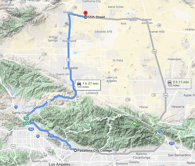
We will meet on Monday, January 19th, 2026 (MLK holiday) at 9:00 AM at the 55th St exit off Hwy 58, approx. 8.2 miles east from Hwy 14 and Mojave Barstow Rd intersection in Mojave. The meeting spot is located 105 miles from Pasadena, about a 1.5-hour drive.
Coordinates: 35°01’13.8″N 118°02’01.1″W (35.020511, -118.033631)
The Google Maps pin: https://goo.gl/maps/uPtAULiEpKtyVRgMA
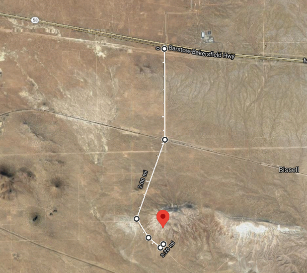
From there we will drive 3.2 miles south on reasonable quality dirt roads to the final turnoff and park at the butte foothill. There is plenty of space for many cars.
The final turnoff coordinates are 34°58’41.1″N 118°02’05.3″W (34.978083, -118.034818)
Note: please do not use this location for directions or Google will take you around on various unrelated roads for 30 miles. Use the first pin instead, then head south on the main dirt road. After crossing the railroad tracks bear slightly right to continue on the main dirt road.
Hope to see you all there,
MarekC