Hi mineral friends!
Let’s visit the Cady Mountains for our next trip on Saturday, Mar 9, 2024. We will get a chance to see some classic rockhounding areas for which we want to protect the future access. We will visit the thulite area in the morning, then the Old Dominion mine in the afternoon.
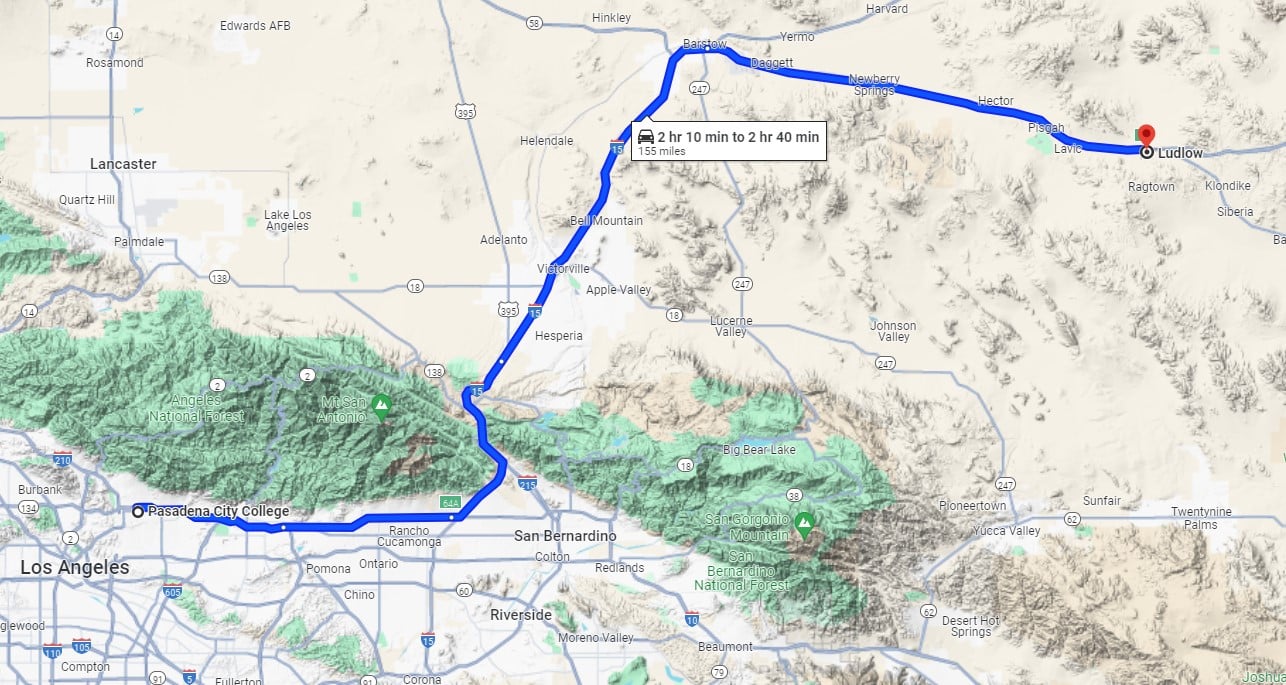
We will meet on Saturday, the 9th, at 9:00 AM in Ludlow, in the parking lot of the Ludlow Cafe, south of Exit 50 from I-40. It’s 155 miles from Pasadena. The driving time is 2+ hours depending on traffic, which should not be bad in the early morning. Here are the GPS coordinates of the meeting place: 34°43’25.0″N 116°09’47.5″W (34.7236, -116.1632). The Google Maps link: https://maps.app.goo.gl/aeStGY5yj5gXXrsC7
The classic thulite area is accessed by driving on the freeway for about 11 miles, then 2 miles on the dirt road that is mostly flat and dusty. No 4WD or high clearance will be necessary, but any low clearance 2WD cars might have a bit of trouble in a few rougher spots. Thulite is the pink variety of mineral zoisite, a member of the epidote group with elongated prismatic crystals. It is found in multiple rock outcrops on the top of a hill visible from the freeway. Most of the material shows massive pink spots intermixed with a pale green matrix. The best pieces exhibit raspberry color. Some of them might have minute crystals up to 1mm, but even without magnification, they will show some sparkle.
For the second part of the trip, we will drive to the Old Dominion mine on the side of the hill next to Broadwell Lake in the heart of the national monument. Many rockhounds collected excellent blue chrysocolla with green malachite needles here in the 60s. The thick veins are long gone today, but the thinner, but bright blue veins covering rocks can still be collected. Also, a much rarer mineral, shattuckite, was found here as well. It is a deep dark blue copper silicate hydroxide forming tufts of fibrous acicular needles on chrysocolla, a hydrated copper aluminum silicate. Gold was also found there.
The path up to the side of the lake is sandy and a bit rough in places, so low clearance is not advisable. The last-mile road to the mine is rougher and quite confusing. If you need a ride, please let me know so we can find you a ride share. The walk up to the dumps is pretty steep, covered with rough rock fragments, requiring good coordination. See the Mindat location for more info: https://www.mindat.org/loc-312606.html
The weather forecast shows balmy 72F and no rain, so join us and enjoy collecting!
Hope to see you there!
MarekC